Subjects : History, Travel
Keywords : ocean, atlas, coast, engraving, hydrography, map, map, navigation, ocean, sea
(Ref : 191947) © Bridgeman Images
Subjects: History, TravelKeywords: ocean, atlas, coast, engraving, hydrography, map, map, navigation, ocean, sea(Ref : 191947) © Bridgeman Images
Customise
Your art print
A chart of the East coast of Scotland f... OF English School
Subjects : History, Travel
Keywords : ocean, atlas, coast, engraving, hydrography, map, map, navigation, ocean, sea
(Ref : 191947) © Bridgeman Images
The artwork
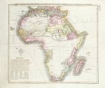
A chart of the East coast of Scotland from a sea-atlas containing an hydrographical description of most of the sea-coasts of the known parts of the world by Samuel Thornton
This artwork is a poster from the classical period. It belongs to the map style.
« A chart of the East coast of Scotland from a sea-atlas containing an hydrographical description of most of the sea-coasts of the known parts of the world by Samuel Thornton » is kept at New York Public Library, New York, United States.
Other artworks by English School
-
From37.83 €£32.1631.53 €£26.8
-
From41.76 €£35.534.8 €£29.58
-
From52.57 €£44.6843.81 €£37.24
-
From53.06 €£45.144.22 €£37.59
-
From46.92 €£39.8839.1 €£33.24
-
From51.59 €£43.8542.99 €£36.54
-
From44.95 €£38.2137.46 €£31.84
-
From50.6 €£43.0142.17 €£35.85
-
From43.97 €£37.3836.64 €£31.15
-
From52.08 €£44.2743.4 €£36.89


Other artworks in the same colors
-
From49.59 €£42.1541.33 €£35.13
-
From41.08 €£34.9234.23 €£29.1
-
From60.06 €£51.0550.05 €£42.54
-
From48.72 €£41.4140.6 €£34.51
-
From49.13 €£41.7640.94 €£34.8


Other similar artworks
-
From38.08 €£32.3731.73 €£26.97
-
From50.11 €£42.641.76 €£35.5
-
From41.27 €£35.0834.39 €£29.23
-
From39.06 €£33.232.55 €£27.67
-
From40.78 €£34.6633.98 €£28.88
-
From38.32 €£32.5731.94 €£27.14
-
From40.29 €£34.2433.57 €£28.54
-
From39.06 €£33.232.55 €£27.67